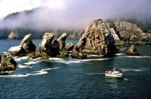
Every month our Emergency Response Division provides scientific expertise and services to the U.S. Coast Guard on everything from running oil spill trajectories to model where the spill may spread, to possible effects on wildlife and fisheries and estimates on how long the oil may stay in the environment. This month OR&R responded to 15 incidents, including oil discharges, sunken vessels, and other pollution-related incidents. Here are some of February's notable incidents ...
Every month our Emergency Response Division provides scientific expertise and services to the U.S. Coast Guard on everything from running oil spill trajectories to model where the spill may spread, to possible effects on wildlife and fisheries and estimates on how long the oil may stay in the environment. This month OR&R responded to eight incidents, including oil discharges, sunken vessels, and other pollution-related incidents. Here are some of January's notable incidents ...
Every month our Emergency Response Division provides scientific expertise and services to the U.S. Coast Guard on everything from running oil spill trajectories to model where the spill may spread, to possible effects on wildlife and fisheries and estimates on how long the oil may stay in the environment. This month OR&R responded to 12 incidents, including oil discharges, sunken vessels, and other pollution-related incidents. Here are some of December's notable incidents ...
By Donna L. Roberts, Office of Response and Restoration
This feature is part of a monthly series profiling scientists and technicians who provide exemplary contributions to the mission of NOAA’s Office of Response and Restoration (OR&R). This month’s featured scientist is Lt. Matthew Bissell, regional response officer for the Pacific Northwest, in OR&R’s Emergency Response Division.
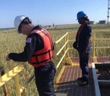
As a response operations supervisor for NOAA’s Office of Response and Restoration, Ed Levine is part of an interdisciplinary scientific team that responds to oil and chemical spills in U.S. waters and helps the U.S. Coast Guard make timely operational decisions during a spill response. Though Ed oversees scientific support coordinators on the East Coast, his work has taken him around the world — from the Galapagos Islands and Uruguay to Portugal and China. But the one place that he keeps going back to is the Panama Canal.
Every month our Emergency Response Division provides scientific expertise and services to the U.S. Coast Guard on everything from running oil spill trajectories to model where the spill may spread, to possible effects on wildlife and fisheries and estimates on how long the oil may stay in the environment.
This month OR&R responded to 12 incidents, including oil discharges, sunken vessels, and other pollution-related incidents. Here are some of November's notable incidents ...
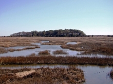
This week, we’re taking a closer look at what sensitivity mapping is, how it’s used, and why it’s so important. A snapshot of the resources in a specific area, sensitivity mapping can be a valuable tool both in and out of the spill response community. In this latest blog, learn more about where sensitivity mapping first got its start, and how mapping specialist Jill Petersen has seen it grow throughout her career.
By Donna L. Roberts, Office of Response and Restoration
This week, we’re taking a closer look at what sensitivity mapping is, how it’s used, and why it’s so important. A snapshot of the resources in a specific area, sensitivity mapping can be a valuable tool both in and out of the spill response community.
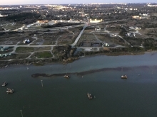
Every month our Emergency Response Division provides scientific expertise and services to the U.S. Coast Guard on everything from running oil spill trajectories to model where the spill may spread, to possible effects on wildlife and fisheries and estimates on how long the oil may stay in the environment. This month OR&R responded to 23 incidents, including oil discharges, sunken vessels, and other pollution-related incidents. Here are some of October's notable incidents ...
By Frank Csulak, Office of Response and Restoration
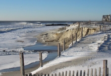
The ocean side of Virginia’s Eastern Shore extends from Assateague Island at the Maryland border to Fisherman’s Island at the foot of the Chesapeake Bay Bridge Tunnel. It is comprised of 23 dynamic islands, made up of sand, wetlands, and lagoons, and is one of the largest undeveloped stretches of shoreline along the East Coast. The Virginia Barrier Islands are remote, ecologically valuable, and highly sensitive to oil spills.